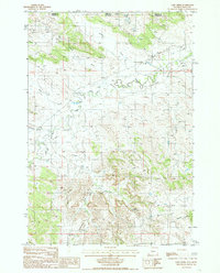
1984 Map of Gaff Creek
USGS Topo · Published 1985About this map
The Little Missouri River meanders through this high plains landscape at the border of Carter and Crook counties, marking the boundary between Montana and Wyoming. The map documents a rugged terrain defined by significant drainage systems such as Government Canyon and Scoggin Draw, which feed into the larger river valley. Industrial activity in the early 1980s is centered around several extractive sites, specifically numerous Claypit labels scattered across the northern sections, suggesting a local reliance on bentonite or similar mineral resources. This survey captures the rural infrastructure of the era, from the network of unimproved roads to isolated water sources like Spring and Well. Named landmarks such as Holben Creek and Sawmill Draw provide specific points of interest for those tracing the history of land use and small-scale ranching along the Gaff Creek drainage.
Find a feature on this map
19 named features on this map. Tap any name to fly to it.
Don’t see what you’re looking for? This feature index may not catch every label — zoom into the map to look around manually.
Map Details
Editions of this 1984 Gaff Creek Map
This is the sole edition of this map. No revisions or reprints were ever made.
Other maps of this area

1901 · Aladdin
USGS Topo · 1:125,000

1903 · Aladdin
USGS Topo · 1:125,000

1905 · Devils Tower
USGS Topo · 1:125,000

1954 · Strawberry Hill
USGS Topo · 1:24,000

1954 · Ekalaka
USGS Topo · 1:250,000

1954 · Gillette
USGS Topo · 1:250,000

1955 · Gillette
USGS Topo · 1:250,000

1956 · Ekalaka
USGS Topo · 1:250,000

1957 · Mona
USGS Topo · 1:62,500

1957 · Seely
USGS Topo · 1:62,500