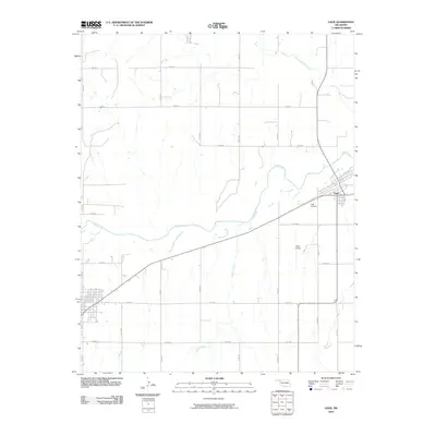
2010 Map of Gage
USGS Topo · Published 2010About this map
Gage serves as the primary hub of activity on this High Plains landscape, situated along the diagonal corridor of the local rail and highway network. The town's grid is established northeast of Wolf Creek, which meanders across the central portion of the quadrangle. Several other watercourses, including Twentyfive Mile Creek and Willow Creek, drain the surrounding terrain, indicating the vital role of riparian corridors in this semi-arid region. To the south of the main settlement, Gage Cemetery and Gage Airport represent significant community landmarks, anchoring the local infrastructure. The map reveals a highly structured section-line road system, with routes like n1760 RD and e0450 RD forming a rigid geometric pattern across the prairie, reflecting the enduring legacy of the Public Land Survey System in Oklahoma.
Find a feature on this map
22 named features on this map. Tap any name to fly to it.
Don’t see what you’re looking for? This feature index may not catch every label — zoom into the map to look around manually.
Map Details
Editions of this 2010 Gage Map
This is the sole edition of this map. No revisions or reprints were ever made.
Other maps of this area

1955 · Woodward
USGS Topo · 1:250,000

1958 · Woodward
USGS Topo · 1:250,000

1969 · Fargo SW
USGS Topo · 1:24,000

1969 · Fargo NW
USGS Topo · 1:24,000

1969 · Shattuck
USGS Topo · 1:24,000

1969 · Shattuck NW
USGS Topo · 1:24,000

1969 · Gage
USGS Topo · 1:24,000

1969 · Shattuck NE
USGS Topo · 1:24,000

1970 · Arnett
USGS Topo · 1:24,000

1970 · Goodwin
USGS Topo · 1:24,000