Old Maps of Ellis County, Oklahoma
Explore 228 old maps of Ellis County, spanning from 1954 to today. These high-resolution historic maps reveal how streets, neighborhoods, landmarks, and natural features evolved over time — perfect for genealogy, metal detecting, research, and local history exploration.
What you can do with these maps:
- See how Ellis County changed over time: Compare historical maps to modern-day views to trace roads, homesites, rail lines & more.
- View detailed metadata: Each map includes creators, publishers, year, scale, and archive source.
- Overlay maps with satellite & LiDAR: Visualize the past alongside modern tools to explore terrain & human change.
- Trusted historical sources: Maps sourced from the USGS, Library of Congress, and other archives.
- Access maps your way: View online, download high-res files, or order prints for personal or research use.
Start exploring old maps of Ellis County to uncover forgotten places, hidden landmarks, and the deep history beneath your feet.
Ellis County, OK maps
(228)- 1954 Map of Perryton, 1966 Print
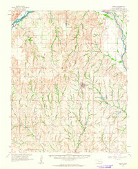
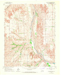
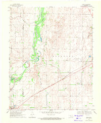
 1954 Perryton1966 Print · USGSThe High Plains of the Texas and Oklahoma panhandles are shown during a period of steady growth in the mid-1950s. Genealogists and researchers can trace rail history and local landmarks like Panhandle A & M College, Spurlock Chapel, and the isolated Lord Station.3 unique versions available
 - 1954 Map of Amarillo, 1966 Print
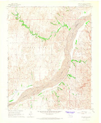
 1954 Amarillo1966 Print · USGSThe Texas Panhandle in the mid-1960s shows a landscape of rising industrial power and deep-rooted ranching tradition. Local historians can trace the paths of the Panhandle and Santa Fe railroad or locate sites like the Pantex Ordnance Plant and Mobeetie.2 unique versions available
 - 1955 Map of Clinton, 1964 Print
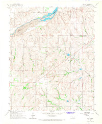
 1955 Clinton1964 Print · USGSWestern Oklahoma during the mid-century transition shows a landscape of growing reservoirs and active military flight lines. Genealogists and historians can locate rural landmarks such as Mountain View Church, Berlin School, and the Riverside Indian School Reserve.3 unique versions available
 - 1955 Map of Woodward, 1967 Print
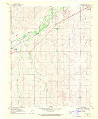
 1955 Woodward1967 Print · USGSNorthwest Oklahoma and the bordering plains are captured during the mid-sixties, showing a landscape defined by river valleys and massive water projects. Researchers can trace family roots in towns like Woodward and Alva or locate landmarks such as the Western Oklahoma State Hospital and Kegelman AF.3 unique versions available
 - 1957 Map of Clinton
 1957 Clinton1957 Print · USGSWestern Oklahoma in the mid-fifties is captured here as a landscape of river-valley settlements and emerging energy fields. Genealogists can trace family roots through numerous rural landmarks like the Swapping Back Indian School, Hebron Church, and the Riverside Indian School Reserve.
 - 1958 Map of Perryton
 1958 Perryton1958 Print · USGSThe Oklahoma Panhandle and Texas borderlands come alive in this mid-century survey, showing the vital rail-and-ranch economy of the High Plains. Researchers can trace historic stops along the Chicago Rock Island and Pacific and locate rural landmarks like Bethel Church and Spurlock Chapel.
 - 1958 Map of Woodward
 1958 Woodward1958 Print · USGSNorthwest Oklahoma and the neighboring panhandle borders are shown here during a period of steady mid-century growth. Researchers can trace the rail networks of the Atchison Topeka and Santa Fe and locate landmarks like the Western Oklahoma State Hospital and Port Supply Reservoir.2 unique versions available
 - 1958 Map of Amarillo
 1958 Amarillo1958 Print · USGSThe Texas Panhandle in the mid-1950s reveals a landscape of expanding military installations and oil-rich rail towns. Local historians can trace the development of Amarillo Air Force Base or locate smaller settlements like Magic City and New Mobeetie.
 - 1961 Map of Leedey, 1963 Print
 1961 Leedey1963 Print · USGSIn the early 1960s, Western Oklahoma's agrarian character was defined by the intersection of rail lines and quiet rural communities. Researchers can trace the legacy of early settlers through numerous landmarks like Evergreen Cem, Liberty Center Ch, and the winding Canadian River.2 unique versions available
 - 1965 Map of Roll NE, 1967 Print
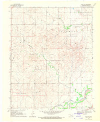
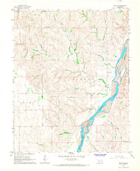 1965 Roll NE1967 Print · USGSThe Canadian River valley dominates this mid-1960s survey along the border of Ellis and Roger Mills counties. Genealogists and local historians can locate the Ioland Cem and trace the paths of Hackberry Creek and Spotted Deer Creek.
 - 1965 Map of Roll NW, 1967 Print
 1965 Roll NW1967 Print · USGSThe border of Ellis and Roger Mills counties comes to life in the mid-1960s as it follows the path of the Canadian River. Genealogists and researchers can trace the vicinity of Streeter or locate industrial markers like an Oil Well and Packsaddle Lake.2 unique versions available
 - 1966 Map of Roll, 1967 Print
 1966 Roll1967 Print · USGSWestern Oklahoma’s prairie landscape is captured here in the mid-1960s, showing the rural character of Roger Mills County. Researchers can locate family landmarks like Silent Home Cem and Pie Flat Cem near the small settlement of Roll.
 - 1966 Map of Antelope Hills NE, 1967 Print
 1966 Antelope Hills NE1967 Print · USGSRoger Mills County in the mid-1960s was a landscape of wide river valleys and emerging energy production. Researchers can locate the Belleview Cem and trace the paths of Sand Creek and Cottonwood Creek as they drain into the Canadian River.
 - 1966 Map of Antelope Hills, 1967 Print
 1966 Antelope Hills1967 Print · USGSWestern Oklahoma in the mid-sixties reveals a landscape shaped by river systems and the oil industry. Researchers can locate family landmarks like Lone Tree Cem or trace the Canadian River and the rise of the Antelope Hills.
 - 1966 Map of Roll SE, 1967 Print
 1966 Roll SE1967 Print · USGSRoger Mills and Ellis counties are captured in the mid-1960s, showing a rural landscape defined by the Canadian River and its many tributaries. Genealogists can locate community landmarks such as Lone Bell Cem, Rhome Cem, and the Three Corner Sch.
 - 1969 Map of Fargo SW, 1970 Print
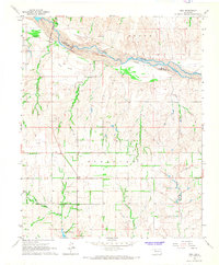
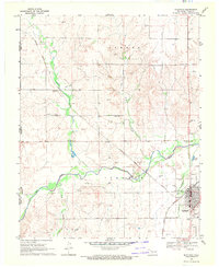
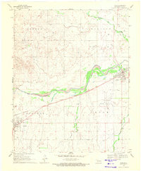
 1969 Fargo SW1970 Print · USGSEllis County's plains are captured here in the late sixties, showing a landscape defined by the arrival of the energy industry. Researchers can trace the Atchison Topeka and Santa Fe rail line past The Artesian Beach Park or locate family roots near Woodrow and the local Cem.
 - 1969 Map of Fargo, 1971 Print
 1969 Fargo1971 Print · USGSWestern Oklahoma’s prairie landscape is captured here in the late sixties, centered on the Atchison Topeka and Santa Fe rail line. Genealogists and researchers can trace the early layouts of Fargo and Tangier, as well as landmarks like Rest Haven Cem and Braunch Memorial Park.
 - 1969 Map of Fargo NW, 1971 Print
 1969 Fargo NW1971 Print · USGSWestern Oklahoma cattle and gas country comes into focus in the late sixties, centered on the drainage of Wolf Creek. Genealogists and researchers can locate Greenwood Ch, Sunset Cem, and the outskirts of Fargo amidst a network of Caliche Pits and section lines.
 - 1969 Map of Shattuck, 1971 Print
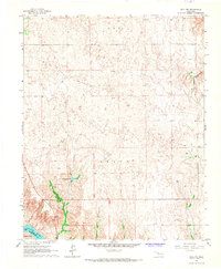
 1969 Shattuck1971 Print · USGSShattuck and western Ellis County appear at a point of steady growth in the late sixties, where the high plains meet the valley of Wolf Creek. Researchers can trace the path of the Atchison Topeka and Santa Fe railroad or locate local landmarks like Touzalin and the Shattuck Airport.2 unique versions available
 - 1969 Map of Vici NW, 1971 Print
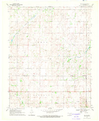 1969 Vici NW1971 Print · USGSWestern Oklahoma’s ranching and oil country is captured here during the late sixties, where county lines follow the Old Indian Treaty Boundary. Researchers can trace the courses of North Persimmon Creek and Turkey Creek alongside landmarks like local Landing Strips and a Caliche Pit.
 - 1969 Map of Shattuck NW, 1971 Print
 1969 Shattuck NW1971 Print · USGSThe Oklahoma Panhandle borderlands are captured here in the late sixties as the local energy economy expanded across the plains. Genealogists and researchers can locate the settlement of Catesby and trace family sites near Bickford Cem and Mt Hope Cem.
 - 1969 Map of Gage, 1971 Print
 1969 Gage1971 Print · USGSGage and Shattuck appear here in the late sixties, connected by the vital rail line of the Atchison Topeka and Santa Fe. Genealogists and local historians can locate the Gage Cem and trace the paths of Wolf Creek and Willow Creek.
 - 1969 Map of Fargo SE, 1971 Print
 1969 Fargo SE1971 Print · USGSThe border of Ellis and Woodward counties was a landscape of remote farmsteads and growing energy sites in the late sixties. Researchers can locate the early footprints of Fargo and Keenan, or trace rural family roots at Fargo Cem and Gnadenfield Cem.
 - 1969 Map of Shattuck NE, 1971 Print
 1969 Shattuck NE1971 Print · USGSEllis County land in the late sixties reveals a landscape shaped by petroleum exploration and rural township boundaries. Researchers can trace resource extraction through numerous Gas Wells and identify local infrastructure like the Radio Tower and Pipeline crossing Twentyfive Mile Creek.
 - 1970 Map of Arnett, 1972 Print
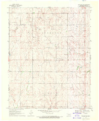
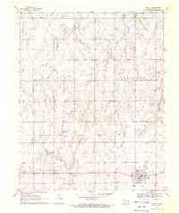 1970 Arnett1972 Print · USGSWestern Oklahoma’s high plains are documented here in the early seventies, centered on the county seat of Arnett. Genealogists and historians can trace the Old Indian Treaty Boundary and locate family sites at Debolt Cem or the Seventh-Day Adventist Cem.
Showing maps 1-25 of 228
Top cities of Ellis County
Frequently asked questions
- What are the different types of historical maps available for Ellis County?
- What is the oldest map of Ellis County?
- Where can I purchase historical maps of Ellis County for my home or office?
- Where can I download high-res historical maps of Ellis County?
- Are there historical topographic maps available for Ellis County?
- Is there historical aerial imagery available for Ellis County?
- Where are historical maps of Ellis County sourced from?