
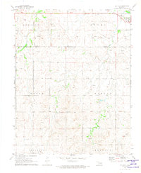
1969 Map of Shattuck NW
USGS Topo · Published 1971About this map
Catesby stands as a focal point in this 1960s survey of the high plains along the Oklahoma-Texas border. The landscape is defined by the headwaters of Ivanhoe Creek and Sixmile Creek, where the drainage patterns reveal a rugged break in the otherwise flat terrain of Jefferson and Athen townships. This era of the Panhandle's history is marked by significant natural resource extraction, evidenced by the numerous Gas Wells and several instances of a Caliche Pit scattered across the township sections. Local genealogy and settlement history are anchored by the Bickford Cem and Mt Hope Cem, which serve as quiet landmarks among the expansive ranching and energy-producing lands. The presence of a prominent Pipeline cutting through the northern sections further underscores the industrial shift toward petroleum in this rural landscape.
Find a feature on this map
13 named features on this map. Tap any name to fly to it.
Don’t see what you’re looking for? This feature index may not catch every label — zoom into the map to look around manually.
Map Details
Editions of this 1969 Shattuck NW Map
This is the sole edition of this map. No revisions or reprints were ever made.
Other maps of this area

1954 · Perryton
USGS Topo · 1:250,000

1955 · Woodward
USGS Topo · 1:250,000

1958 · Perryton
USGS Topo · 1:250,000

1958 · Woodward
USGS Topo · 1:250,000

1969 · Shattuck
USGS Topo · 1:24,000

1969 · Gage
USGS Topo · 1:24,000

1969 · Shattuck NE
USGS Topo · 1:24,000

1970 · Laverne SW
USGS Topo · 1:24,000

1971 · Slapout
USGS Topo · 1:24,000
1971 · May West
USGS Topo · 1:24,000