
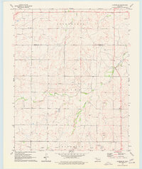
1970 Map of Laverne SW
USGS Topo · Published 1973About this map
The boundary between Harper and Ellis Counties defines this landscape in northwestern Oklahoma, where the energy industry is a visible driver of the local economy. Dozens of Gas Wells and an extensive network of Pipelines crisscross the townships of Speermoore, Otter, and Jefferson, illustrating the intense resource extraction occurring in the early 1970s. The terrain is deeply dissected by drainage systems, most notably Spring Creek and Clear Creek, which join with Dry Prong to carve the rolling surface of the High Plains.
Find a feature on this map
11 named features on this map. Tap any name to fly to it.
Don’t see what you’re looking for? This feature index may not catch every label — zoom into the map to look around manually.
Map Details
Editions of this 1970 Laverne SW Map
2 editions found
Other maps of this area

1954 · Perryton
USGS Topo · 1:250,000

1955 · Woodward
USGS Topo · 1:250,000

1958 · Perryton
USGS Topo · 1:250,000

1958 · Woodward
USGS Topo · 1:250,000

1969 · Shattuck NW
USGS Topo · 1:24,000

1969 · Shattuck NE
USGS Topo · 1:24,000

1971 · Logan NE
USGS Topo · 1:24,000

1971 · Slapout
USGS Topo · 1:24,000
1971 · Laverne
USGS Topo · 1:24,000

1971 · Laverne NE
USGS Topo · 1:24,000