
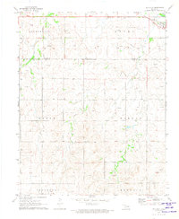
1969 Map of Shattuck NE
USGS Topo · Published 1971About this map
Twentyfive Mile Creek winds through this northwestern Oklahoma landscape, carving a detailed drainage pattern through the townships of Jefferson, Murdock, Athens, and Woodrow. This 1969 survey captures the region during a period of active natural resource extraction, evidenced by the numerous Gas Wells and Drill Holes scattered across the terrain. The map serves as a precise record of the industrial infrastructure of the late 1960s, showing the path of a major Pipeline and several Caliche Pits used for local road building and surfacing. Smaller watercourses like Sixteenmile Creek feed into the primary valley, illustrating the complex hydrology of Ellis County. Near the southern edge, a Sandpit and a prominent Radio Tower stand as distinctive local landmarks among the section lines and rural tracks.
Find a feature on this map
13 named features on this map. Tap any name to fly to it.
Don’t see what you’re looking for? This feature index may not catch every label — zoom into the map to look around manually.
Map Details
Editions of this 1969 Shattuck NE Map
This is the sole edition of this map. No revisions or reprints were ever made.
Other maps of this area

1955 · Woodward
USGS Topo · 1:250,000

1958 · Woodward
USGS Topo · 1:250,000

1969 · Fargo SW
USGS Topo · 1:24,000

1969 · Fargo NW
USGS Topo · 1:24,000

1969 · Shattuck
USGS Topo · 1:24,000

1969 · Shattuck NW
USGS Topo · 1:24,000

1969 · Gage
USGS Topo · 1:24,000

1970 · Laverne SW
USGS Topo · 1:24,000

1971 · May East
USGS Topo · 1:24,000
1971 · May West
USGS Topo · 1:24,000