
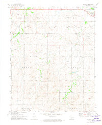
1971 Map of May East
USGS Topo · Published 1973About this map
The settlement of May sits in the northwest corner of this Oklahoma landscape, situated just south of the Beaver River during the early 1970s. The map illustrates a region transitioning from the river lowlands into the dissected uplands of Morgan and Murdock. Industrial activity is evident throughout the terrain, marked by numerous Gas Wells and an Oil Well, alongside a prominent north-south Pipeline that cuts across the eastern sections.
Find a feature on this map
15 named features on this map. Tap any name to fly to it.
Don’t see what you’re looking for? This feature index may not catch every label — zoom into the map to look around manually.
Map Details
Editions of this 1971 May East Map
This is the sole edition of this map. No revisions or reprints were ever made.
Other maps of this area

1955 · Woodward
USGS Topo · 1:250,000

1958 · Woodward
USGS Topo · 1:250,000

1969 · Fargo
USGS Topo · 1:24,000

1969 · Fargo NW
USGS Topo · 1:24,000

1969 · Shattuck NE
USGS Topo · 1:24,000

1971 · Fort Supply
USGS Topo · 1:24,000

1971 · Fort Supply NW
USGS Topo · 1:24,000

1971 · Fort Supply NE
USGS Topo · 1:24,000

1971 · Laverne NE
USGS Topo · 1:24,000
1971 · May West
USGS Topo · 1:24,000