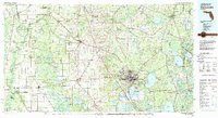
1981 Map of Gainesville
USGS Topo · Published 1982About this map
Gainesville serves as the regional hub for North Central Florida in the early 1980s, flanked by the sprawling wetlands of Paynes Prairie State Preserve and the academic grounds of the Univ of Fla Agr Exper Sta. The map reveals a landscape defined by its distinctive hydrogeology, from the sinkhole at Devil's Millhopper to the clear runs of Ichetucknee Springs State Park. Commercial transit is anchored by the Seaboard Coast Line and Georgia Southern and Florida railroads, which connect smaller agricultural communities such as Archer, Newberry, and Hawthorne. To the northeast, the massive Camp Blanding Military Reservation dominates the boundary near Kingsley Lake. This period shows the transition from rural timber and farming hamlets like Wacahoota and Arredondo toward modern suburbanization, while significant protected lands like San Felasco Hammock State Preserve remain preserved among the development.
Find a feature on this map
135 named features on this map. Tap any name to fly to it.
Don’t see what you’re looking for? This feature index may not catch every label — zoom into the map to look around manually.
Map Details
Editions of this 1981 Gainesville Map
2 editions found
Other maps of this area

1890 · Arredondo
USGS Topo · 1:62,500

1892 · Arredondo
USGS Topo · 1:62,500

1893 · Citra
USGS Topo · 1:62,500

1894 · Arredondo
USGS Topo · 1:62,500

1895 · Williston
USGS Topo · 1:62,500

1895 · Citra
USGS Topo · 1:62,500

1915 · Interlachen
USGS Topo · 1:48,000

1916 · Interlachen
USGS Topo · 1:62,500

1918 · Middleburg
USGS Topo · 1:62,500

1918 · Lawtey
USGS Topo · 1:62,500