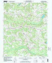
1997 Map of Galatia
USGS Topo · Published 2000About this map
Potecasi Creek and its extensive swamp networks define this part of Northampton County, where the landscape is marked by centuries of agricultural settlement and rural community centers. Small crossroads and hamlets such as Galatia, Faisons, and Creeksville serve as anchor points for the surrounding farmland. The map documents numerous rural institutions, including Zion Hill Ch, St Johns Ch, and the County High Sch, reflecting the social geography of the late 20th century. The hydrology of the region is notably controlled by historic water features like Debary Millpond and Doolittle Millpond, which transition into the dense vegetation of Corduroy Swamp and Wiccacanee Swamp. These drainage patterns, including Paddy Delight Creek, illustrate the historical reliance on local watercourses for both boundary-marking and industry in this coastal plain environment.
Find a feature on this map
23 named features on this map. Tap any name to fly to it.
Don’t see what you’re looking for? This feature index may not catch every label — zoom into the map to look around manually.
Map Details
Editions of this 1997 Galatia Map
This is the sole edition of this map. No revisions or reprints were ever made.
Other maps of this area

1919 · Boykins
USGS Topo · 1:48,000

1919 · Arringdale
USGS Topo · 1:48,000

1920 · Boykins
USGS Topo · 1:62,500

1920 · Arringdale
USGS Topo · 1:62,500

1942 · Arringdale
USGS Topo · 1:62,500

1953 · Norfolk
USGS Topo · 1:250,000

1966 · Margarettsville
USGS Topo · 1:24,000
1966 · Claresville
USGS Topo · 1:24,000
1966 · Boykins
USGS Topo · 1:24,000
1973 · Conway
USGS Topo · 1:24,000