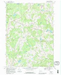
1992 Map of Galilee
USGS Topo · Published 1995About this map
The rolling landscape of Wayne County is defined by a dense network of mountain streams and glacial ponds, serving as a backdrop for quiet agricultural settlements. Small crossroads communities like Rileyville and Boyds Mills remain connected by winding roads and jeep trails, reflecting a rural lifestyle that persisted into the late 20th century. Cultural life is anchored by country churches, including St Josephs Ch and Rileyville Ch, alongside well-placed burying grounds such as Hillcrest Cem. Large portions of the terrain are dedicated to conservation, notably State Game Lands No 159 in the northwest corner. Water is a central theme throughout the quadrangle, from the expansive Duck Harbor Pond to the secluded Lovelace Pond, providing insight into the region's drainage patterns and historical reliance on local water sources.
Find a feature on this map
46 named features on this map. Tap any name to fly to it.
Don’t see what you’re looking for? This feature index may not catch every label — zoom into the map to look around manually.
Map Details
Editions of this 1992 Galilee Map
This is the sole edition of this map. No revisions or reprints were ever made.
Other maps of this area

1892 · Honesdale
USGS Topo · 1:62,500

1920 · Long Eddy
USGS Topo · 1:62,500

1920 · Damascus
USGS Topo · 1:62,500

1921 · Long Eddy
USGS Topo · 1:48,000

1923 · Damascus
USGS Topo · 1:62,500

1923 · Long Eddy
USGS Topo · 1:62,500

1926 · Starrucca
USGS Topo · 1:62,500

1930 · Starrucca
USGS Topo · 1:48,000

1933 · Starrucca
USGS Topo · 1:62,500

1943 · Honesdale
USGS Topo · 1:125,000