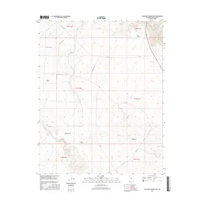
2017 Map of Gallegos Trading Post
USGS Topo · Published 2017About this map
Gallegos Trading Post serves as a central landmark in this high-desert landscape of San Juan County, New Mexico, where a network of tribal and county routes connects scattered settlements and seasonal water sources. The terrain is defined by dramatic erosion, featuring deep incisions like Gallegos Canyon and Cedar Canyon that drain toward the northwest. Modern infrastructure is represented by a web of designated service roads including Indian Svc Rte 4043 and Indian Svc Rte 4022, which follow the natural contours of the mesas. Small pockets of life persist near water sources such as Pete Spring, while the community of Huerfano sits at a junction of regional roads in the southeastern portion of the quadrangle. This 2017 survey illustrates the enduring relationship between the local road network and the challenging canyon topography of the Eastern Navajo Agency.
Find a feature on this map
25 named features on this map. Tap any name to fly to it.
Don’t see what you’re looking for? This feature index may not catch every label — zoom into the map to look around manually.
Map Details
Editions of this 2017 Gallegos Trading Post Map
This is the sole edition of this map. No revisions or reprints were ever made.
Other maps of this area

1889 · Largo
USGS Topo · 1:250,000

1889 · Chaco
USGS Topo · 1:250,000

1892 · Chaco
USGS Topo · 1:250,000

1895 · Largo
USGS Topo · 1:250,000

1954 · Shiprock
USGS Topo · 1:250,000

1954 · Aztec
USGS Topo · 1:250,000

1958 · Shiprock
USGS Topo · 1:250,000

1958 · Aztec
USGS Topo · 1:250,000

1959 · Shiprock
USGS Topo · 1:250,000

1960 · Bloomfield
USGS Topo · 1:62,500
Featured Places
- Eastern Navajo Agency, NM
- Teeł Sikaad, Eastern Navajo Agency
- Huerfano, Eastern Navajo Agency
- San Juan County, NM
- United States