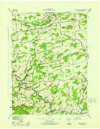
1946 Map of Gallupville
USGS Topo · Published 1946About this map
Gallupville and the winding valley of Fox Creek define this mid-century landscape where Schoharie, Schenectady, and Albany counties converge. The area’s rural character is marked by a network of numbered school districts and family-named landmarks like Zimmer Hill and Barton Hill Cem. In the north, the village of Delanson and the neighboring Quaker Street sit along the Delaware and Hudson Road, serving as a hub for the surrounding agricultural uplands. Many small-scale features, such as St Peters Chapel and School No 11, highlight the density of local community life before major post-war consolidation. The terrain transitions from the steep hillsides of Wright to the flatter reaches of Duanesburg, with numerous small cemeteries like Grove Cem and Woodlawn Cem preserved near established settlements like West Berne and Berne.
Find a feature on this map
45 named features on this map. Tap any name to fly to it.
Don’t see what you’re looking for? This feature index may not catch every label — zoom into the map to look around manually.
Map Details
Editions of this 1946 Gallupville Map
This is the sole edition of this map. No revisions or reprints were ever made.
Other maps of this area

1895 · Amsterdam
USGS Topo · 1:62,500

1896 · Fonda
USGS Topo · 1:62,500

1898 · Fonda
USGS Topo · 1:62,500

1898 · Schoharie
USGS Topo · 1:62,500

1900 · Schoharie
USGS Topo · 1:62,500

1900 · Schoharie
USGS Topo · 1:31,680

1900 · Berne
USGS Topo · 1:62,500

1902 · Fonda
USGS Topo · 1:62,500

1903 · Berne
USGS Topo · 1:62,500

1931 · Amsterdam
USGS Topo · 1:62,500