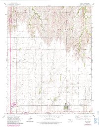
1965 Map of Galva
USGS Topo · Published 1985About this map
Galva stands as a focal point in this agricultural landscape of McPherson County, where the rail lines of the St Louis Atchison Topeka and Santa Fe provide a vital connection for the region's economy. The settlement patterns of the mid-20th century are evident in the proximity of a Trailer Park to the town center and the rural social hubs of New Gottland Ch and Harmony Sch. The terrain is defined by a series of waterways, including Kentucky Creek, Gypsum Creek, and Dry Turkey Creek, which wind through the various townships such as New Gottland and Delmore. Industrial markers like the Quarry, scattered Gas Wells, and the Oil Field show the diversification of land use beyond farming. Local family legacies are preserved in named points like Chindberg, reflecting the deep-rooted community history of the Kansas plains during this era of post-war development.
Find a feature on this map
22 named features on this map. Tap any name to fly to it.
Don’t see what you’re looking for? This feature index may not catch every label — zoom into the map to look around manually.
Map Details
Editions of this 1965 Galva Map
3 editions found

Other maps of this area

1889 · Newton
USGS Topo · 1:125,000

1889 · Abilene
USGS Topo · 1:125,000

1891 · Hutchinson
USGS Topo · 1:125,000

1892 · Salina
USGS Topo · 1:125,000

1893 · Hutchinson
USGS Topo · 1:125,000

1894 · Newton
USGS Topo · 1:125,000

1894 · Abilene
USGS Topo · 1:125,000

1942 · Salina
USGS Topo · 1:125,000

1955 · Hutchinson
USGS Topo · 1:250,000

1959 · Hutchinson
USGS Topo · 1:250,000