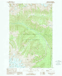
1988 Map of Gamma Peak
USGS Topo · Published 1988About this map
Glacier Peak Wilderness dominates this high-altitude landscape in the late 1980s, revealing a terrain defined by active glaciation and difficult access. Significant glacial systems, including the Ptarmigan, Vista, and Ermine, drape the southern peaks around Kennedy Peak and Gamma Peak. The Suiattle River serves as the primary drainage, fed by numerous high-mountain streams like Miners Creek and Dusty Creek.
Find a feature on this map
34 named features on this map. Tap any name to fly to it.
Don’t see what you’re looking for? This feature index may not catch every label — zoom into the map to look around manually.
Map Details
Editions of this 1988 Gamma Peak Map
2 editions found
Other maps of this area

1899 · Glacier Peak
USGS Topo · 1:125,000

1901 · Glacier Peak
USGS Topo · 1:125,000

1902 · Stehekin
USGS Topo · 1:125,000

1904 · Stehekin
USGS Topo · 1:125,000

1944 · Holden
USGS Topo · 1:62,500

1949 · Holden
USGS Topo · 1:62,500

1950 · Glacier Peak
USGS Topo · 1:62,500

1955 · Concrete
USGS Topo · 1:250,000

1958 · Concrete
USGS Topo · 1:250,000

1962 · Concrete
USGS Topo · 1:250,000