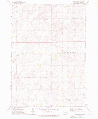
1973 Map of Gannvalley SE
USGS Topo · Published 1976About this map
Harmony Ch stands as a local landmark in the northeastern corner of this rural landscape, situated within the Harmony township area. The terrain here is defined by its agricultural and prairie character, organized into distinct townships including Pleasant, Logan, and Crow Lake. Evidence of local industry and infrastructure is visible through scattered Gravel Pits, while the undulating topography reveals the complex drainage patterns of the region. The map captures a moment in the mid-1970s before modern consolidation, showing the precise placement of section lines and township boundaries like Marlar and Crow that have historically organized this Jerauld County landscape for generations of farming families.
Find a feature on this map
8 named features on this map. Tap any name to fly to it.
Don’t see what you’re looking for? This feature index may not catch every label — zoom into the map to look around manually.
Map Details
Editions of this 1973 Gannvalley SE Map
This is the sole edition of this map. No revisions or reprints were ever made.
Other maps of this area

1941 · Kimball North
USGS Topo · 1:62,500

1942 · Crow Lake
USGS Topo · 1:62,500

1951 · Kimball North
USGS Topo · 1:62,500

1953 · Huron
USGS Topo · 1:250,000

1954 · Huron
USGS Topo · 1:250,000

1955 · Mitchell
USGS Topo · 1:250,000

1959 · Mitchell
USGS Topo · 1:250,000

1973 · Gannvalley
USGS Topo · 1:24,000

1973 · Cottonwood Lake
USGS Topo · 1:24,000

1973 · Wessington Springs NW
USGS Topo · 1:24,000
Featured Places
- Harmony Township, SD
- Logan Township, SD
- Crow Lake Township, SD
- Pleasant Township, SD
- Marlar Township, SD