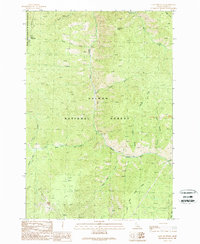
1989 Map of Gant Mountain
USGS Topo · Published 1989About this map
Panther Creek bisects this mountainous landscape, carving a deep valley through the heart of the Salmon National Forest. The 1989 survey reveals a terrain defined by mineral exploration and isolation, with several prospects and an Open Pit Mine located in the southern reaches of the quadrangle. High points like Gant Mountain and Dutchmans Hump overlook a network of drainage systems, including Big Deer Creek and Birch Creek, which are accessible primarily via rugged 4wd tracks and a Pack Trail. Small level areas like Fritzer Flat and Trapper Flat offer rare breaks in the steep topography, while the western edge of the map enters the Frank Church-River of No Return Wilderness. The presence of numerous adits and mining sites highlights the region's historical reliance on extraction within the Idaho backcountry.
Find a feature on this map
32 named features on this map. Tap any name to fly to it.
Don’t see what you’re looking for? This feature index may not catch every label — zoom into the map to look around manually.
Map Details
Editions of this 1989 Gant Mountain Map
This is the sole edition of this map. No revisions or reprints were ever made.
Other maps of this area

1950 · Blackbird Mtn
USGS Topo · 1:62,500

1950 · Leesburg
USGS Topo · 1:62,500

1951 · Leesburg
USGS Topo · 1:62,500

1951 · Blackbird Mtn
USGS Topo · 1:62,500

1956 · Elk City
USGS Topo · 1:250,000

1960 · Elk City
USGS Topo · 1:250,000

1960 · Ulysses Mtn
USGS Topo · 1:62,500

1960 · Shoup
USGS Topo · 1:62,500

1982 · Bighorn Crags
USGS Topo · 1:100,000
1989 · Blackbird Mountain
USGS Topo · 1:24,000