
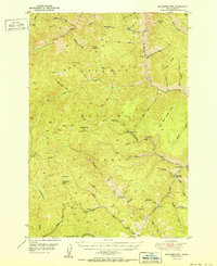
1951 Map of Blackbird Mtn
USGS Topo · Published 1951About this map
Blackbird Mine and several neighboring operations serve as focal points for this mid-century survey of the Lemhi County backcountry. The industrial footprint of the Cobalt Mine and Sunshine Mine contrasts with the isolated ranches and administrative outposts that dot the drainage of Panther Creek. The landscape is dominated by high-elevation ridges like Gant Ridge and Porphyry Ridge, where the Red Rock Pk Lookout and Blackbird Mtn provide vantage points over the vast timberlands of the Salmon National Forest. Remote outposts such as Forney and the Miller Ranch are connected by a network of primitive trails and improved dirt roads, illustrating the logistical challenges of mining and forestry in the interior West. The map captures a transition period where active resource extraction coincided with established ranching at Degan Ranch and the seasonal presence of Squaw Camp in the northern reaches.
Find a feature on this map
54 named features on this map. Tap any name to fly to it.
Don’t see what you’re looking for? This feature index may not catch every label — zoom into the map to look around manually.
Map Details
Editions of this 1951 Blackbird Mtn Map
2 editions found
Other maps of this area

1930 · Casto
USGS Topo · 1:125,000

1950 · Blackbird Mtn
USGS Topo · 1:62,500

1950 · Leesburg
USGS Topo · 1:62,500

1951 · Leesburg
USGS Topo · 1:62,500

1956 · Elk City
USGS Topo · 1:250,000

1957 · Challis
USGS Topo · 1:250,000

1960 · Elk City
USGS Topo · 1:250,000

1960 · Challis
USGS Topo · 1:250,000

1960 · Ulysses Mtn
USGS Topo · 1:62,500

1960 · Shoup
USGS Topo · 1:62,500