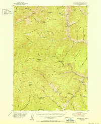
1951 Map of Blackbird Mtn
USGS Topo · Published 1951About this map
Salmon National Forest defines the high-altitude landscape of Lemhi County, Idaho, during the early 1950s. This survey reveals an era of transition for the local mining economy, specifically focused around the Blackbird Mine and several inactive sites such as the Sunshine Mine, Cobalt Mine, and Musgrove Mine. These operations, clustered along the steep drainages of Blackbird Cr and Panther Creek, highlight the region's historical reliance on mineral extraction.
Find a feature on this map
57 named features on this map. Tap any name to fly to it.
Don’t see what you’re looking for? This feature index may not catch every label — zoom into the map to look around manually.
Map Details
Editions of this 1951 Blackbird Mtn Map
2 editions found
Other maps of this area

1930 · Casto
USGS Topo · 1:125,000

1950 · Blackbird Mtn
USGS Topo · 1:62,500

1950 · Leesburg
USGS Topo · 1:62,500

1951 · Leesburg
USGS Topo · 1:62,500

1951 · Blackbird Mtn
USGS Topo · 1:62,500

1956 · Elk City
USGS Topo · 1:250,000

1957 · Challis
USGS Topo · 1:250,000

1960 · Elk City
USGS Topo · 1:250,000

1960 · Challis
USGS Topo · 1:250,000

1960 · Ulysses Mtn
USGS Topo · 1:62,500