
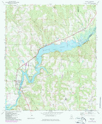
1971 Map of Gantt
USGS Topo · Published 1973About this map
Gantt Lake dominates this 1970s landscape, formed by the impoundment of the Conecuh River along the border of Covington and Crenshaw counties. This era reveals a transition from traditional river-bottom agriculture to a community centered around the reservoir, though the legacy of the timber and rail era persists via the Central of Georgia railroad line. The map highlights a series of small rural communities and church-centered settlements including Straughn, Searight, and Valley of Shiloh. Genealogists and local historians can locate numerous country landmarks such as Zion Chapel Ch, Shady Grove Ch, and the Gantt Cem near the town of Gantt. The topography is defined by the winding river valley and its tributaries like Sims Mill Creek and Feagin Creek, while industrial presence is noted at the Powerplant Substa downstream from the main lake.
Find a feature on this map
48 named features on this map. Tap any name to fly to it.
Don’t see what you’re looking for? This feature index may not catch every label — zoom into the map to look around manually.
Map Details
Editions of this 1971 Gantt Map
2 editions found
Other maps of this area

1953 · Andalusia
USGS Topo · 1:250,000

1957 · Andalusia
USGS Topo · 1:250,000

1971 · Dozier
USGS Topo · 1:24,000

1971 · Industry
USGS Topo · 1:24,000

1971 · Brantley
USGS Topo · 1:24,000

1971 · River Falls
USGS Topo · 1:24,000

1971 · Andalusia
USGS Topo · 1:24,000

1971 · Leon
USGS Topo · 1:24,000

1971 · Red Level
USGS Topo · 1:24,000
1971 · Opp West
USGS Topo · 1:24,000