
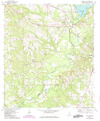
1971 Map of River Falls
USGS Topo · Published 1973About this map
The Conecuh River meanders through the heart of Covington County, defining the landscape between the rural township of River Falls and the expanding western edge of Andalusia. This early 1970s survey illustrates a region defined by its water and timber resources, where the Louisville and Nashville railroad crosses the river just south of Point A Lake. The map reveals a dense network of country churches and cemeteries, such as Presley Chapel, First Bethlehem Ch, and Bethlehem Cem, which serve as vital markers for family history researchers.
Find a feature on this map
44 named features on this map. Tap any name to fly to it.
Don’t see what you’re looking for? This feature index may not catch every label — zoom into the map to look around manually.
Map Details
Editions of this 1971 River Falls Map
2 editions found
Other maps of this area

1953 · Andalusia
USGS Topo · 1:250,000

1957 · Andalusia
USGS Topo · 1:250,000

1971 · Dixie
USGS Topo · 1:24,000

1971 · Brooks
USGS Topo · 1:24,000

1971 · Carolina
USGS Topo · 1:24,000

1971 · Libertyville
USGS Topo · 1:24,000

1971 · Andalusia
USGS Topo · 1:24,000

1971 · Gantt
USGS Topo · 1:24,000

1971 · Red Level
USGS Topo · 1:24,000

1971 · Loango
USGS Topo · 1:24,000