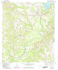
1971 Map of River Falls
USGS Topo · Published 1984About this map
River Falls and the western outskirts of Andalusia dominate this landscape during a period of transition in Covington County. The Conecuh River serves as the central geographic anchor, winding southward past the Point A Lake and its associated Powerplant. Transportation and industry are defined by the Seaboard railroad line, which crosses the river near Patsaliga Cr.
Find a feature on this map
45 named features on this map. Tap any name to fly to it.
Don’t see what you’re looking for? This feature index may not catch every label — zoom into the map to look around manually.
Map Details
Editions of this 1971 River Falls Map
2 editions found
Other maps of this area

1953 · Andalusia
USGS Topo · 1:250,000

1957 · Andalusia
USGS Topo · 1:250,000

1971 · Dixie
USGS Topo · 1:24,000

1971 · Brooks
USGS Topo · 1:24,000

1971 · Carolina
USGS Topo · 1:24,000

1971 · Libertyville
USGS Topo · 1:24,000

1971 · River Falls
USGS Topo · 1:24,000

1971 · Andalusia
USGS Topo · 1:24,000

1971 · Gantt
USGS Topo · 1:24,000

1971 · Red Level
USGS Topo · 1:24,000