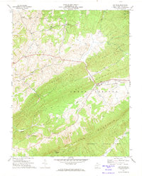
1971 Map of Gap Mills
USGS Topo · Published 1974About this map
Gap Mills serves as the central hub of this Monroe County landscape, situated where the waters of Second Creek cut through the formidable ridges of Gap Mountain. The settlement pattern follows the fertile breaks of Sweet Springs Valley, where local life centered around rural landmarks like Browns Chapel and Carmel Ch. To the south, the massive incline of Peters Mountain forms a natural boundary, sheltering the Jefferson National Forest and the Hanging Rock lookout.
Find a feature on this map
39 named features on this map. Tap any name to fly to it.
Don’t see what you’re looking for? This feature index may not catch every label — zoom into the map to look around manually.
Map Details
Editions of this 1971 Gap Mills Map
This is the sole edition of this map. No revisions or reprints were ever made.
Other maps of this area

1887 · Hinton
USGS Topo · 1:125,000

1887 · Lewisburg
USGS Topo · 1:125,000

1890 · Dublin
USGS Topo · 1:125,000

1890 · Christiansburg
USGS Topo · 1:125,000

1891 · Lewisburg
USGS Topo · 1:125,000

1891 · Dublin
USGS Topo · 1:125,000

1892 · Hinton
USGS Topo · 1:125,000

1921 · Alderson
USGS Topo · 1:48,000

1921 · Ronceverte
USGS Topo · 1:48,000

1923 · Ronceverte
USGS Topo · 1:62,500