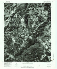
1977 Map of Garden City
USGS Topo · Published 1983About this map
The Roanoke city outskirts and the neighboring valleys of the Blue Ridge are shown here as they appeared in the late 1970s. This orthophotoquad provides a photographic view of the landscape, capturing the suburban development extending into Garden City and Cave Spring before the further expansion of the late 20th century. The terrain is defined by the prominent Buck Mountain and the watercourse of Back Creek, which winds through a series of smaller settlements including Clearbrook, Starkey, and Wright. To the north, the Roanoke River cuts through the more densely settled urban areas, while the eastern edge transition toward the rural communities of Leslie and Dundee. The aerial imagery reveals the precise pattern of forest cover, farm clearings, and the early subdivision footprints that shaped this portion of the Roanoke Valley.
Find a feature on this map
13 named features on this map. Tap any name to fly to it.
Don’t see what you’re looking for? This feature index may not catch every label — zoom into the map to look around manually.
Map Details
Editions of this 1977 Garden City Map
This is the sole edition of this map. No revisions or reprints were ever made.
Other maps of this area

1890 · Roanoke
USGS Topo · 1:125,000

1890 · Christiansburg
USGS Topo · 1:125,000

1891 · Roanoke
USGS Topo · 1:125,000

1929 · Roanoke
USGS Topo · 1:48,000

1929 · Salem
USGS Topo · 1:48,000

1932 · Salem
USGS Topo · 1:62,500

1933 · Roanoke
USGS Topo · 1:62,500

1947 · Roanoke
USGS Topo · 1:250,000

1950 · Elliston
USGS Topo · 1:62,500

1951 · Boones Mill
USGS Topo · 1:62,500