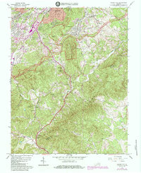
1984 Map of Garden City
USGS Topo · Published 1984About this map
Roanoke and its suburban periphery are captured here during a period of significant mid-century expansion into the surrounding ridges. The landscape is defined by the steep transition from the urban valley up toward Mill Mtn, Stone Mtn, and the winding Blue Ridge Parkway. Along the lower slopes, established communities like Garden City and Cave Spring show dense residential development, while the southern reaches of the map remain dominated by rural homesteads and family cemeteries. The Norfolk and Western Railway corridors and major routes south toward Clearbrook highlight the transportation network that facilitated the city's growth. Cultural and educational landmarks, including the Va Western Community College and several small rural congregations like Boones Chapel, illustrate the community's civic life. Further south, the terrain becomes increasingly complex as the drainage of Back Creek and Gills Creek carves through the foothills of Buck Mountain.
Find a feature on this map
70 named features on this map. Tap any name to fly to it.
Don’t see what you’re looking for? This feature index may not catch every label — zoom into the map to look around manually.
Map Details
Editions of this 1984 Garden City Map
This is the sole edition of this map. No revisions or reprints were ever made.
Other maps of this area

1890 · Roanoke
USGS Topo · 1:125,000

1890 · Christiansburg
USGS Topo · 1:125,000

1891 · Roanoke
USGS Topo · 1:125,000

1929 · Roanoke
USGS Topo · 1:48,000

1929 · Salem
USGS Topo · 1:48,000

1932 · Salem
USGS Topo · 1:62,500

1933 · Roanoke
USGS Topo · 1:62,500

1947 · Roanoke
USGS Topo · 1:250,000

1950 · Elliston
USGS Topo · 1:62,500

1951 · Boones Mill
USGS Topo · 1:62,500