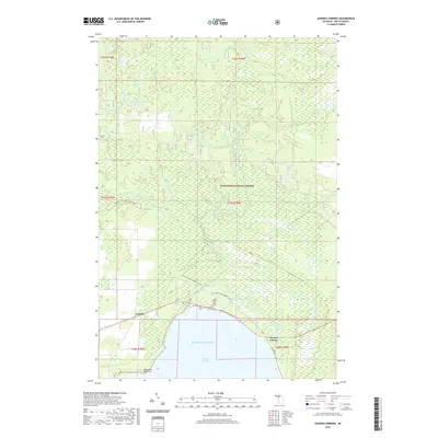
2019 Map of Garden Corners
USGS Topo · Published 2019About this map
Hiawatha National Forest dominates this northern Michigan landscape, where a complex network of waterways drains into Big Bay de Noc along the northern shore of Lake Michigan. The map illustrates a transitional zone between the protected timberlands and the coastal settlements of Isabella and Garden Corners. The drainage pattern is particularly intricate, featuring the Fishdam River and its various tributaries such as Camp Eleven Cr and Camp Twelve Cr, alongside smaller bodies of water like Cousineau Lake and Warner Lake. These names, including several numbered "Camp" creeks, suggest a history tied to seasonal logging or hunting camps within the forest interior. Modern recreational use is visible through the Big Bay de Noc Snomo (Snow) trail, which traverses the shoreline and forest, while Porcupine Point defines a notable geographic landmark at the edge of the bay.
Find a feature on this map
25 named features on this map. Tap any name to fly to it.
Don’t see what you’re looking for? This feature index may not catch every label — zoom into the map to look around manually.
Map Details
Editions of this 2019 Garden Corners Map
This is the sole edition of this map. No revisions or reprints were ever made.
Other maps of this area

1931 · Steuben SW
USGS Topo · 1:31,680

1931 · Cooks NW
USGS Topo · 1:31,680

1932 · Garden NW and SW
USGS Topo · 1:31,680

1932 · Skeels Lake SE
USGS Topo · 1:31,680

1932 · Garden SE
USGS Topo · 1:31,680

1932 · Skeels Lake NW and SW
USGS Topo · 1:31,680

1932 · Garden NE
USGS Topo · 1:31,680

1954 · Escanaba
USGS Topo · 1:250,000

1957 · Escanaba
USGS Topo · 1:250,000

1958 · Escanaba
USGS Topo · 1:250,000