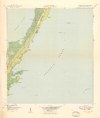
1949 Map of Garden Cove
USGS Topo · Published 1949About this map
Key Largo's eastern coastline is documented here during the late 1940s, a period when the northern stretch of the island remained largely dominated by the Basin Hills and coastal mangroves. The settlement of Garden Cove serves as a focal point along the western shore, positioned near Lake Surprise and the intracoastal waters of Barnes Sound. Inland, the map reveals isolated residences and small named points such as House (South Gable), Baker, and Khowlson along the main road corridor, now known as State Road 905. The coastal geography is defined by intricate tidal features including Rattlesnake Creek and Whitmore Bight. Navigational markers like Basin Hill Lt No 31 and Elbow Reef Beacon B offshore at The Elbow emphasize the area's importance to maritime traffic between the Atlantic Ocean and the protected sounds.
Find a feature on this map
60 named features on this map. Tap any name to fly to it.
Don’t see what you’re looking for? This feature index may not catch every label — zoom into the map to look around manually.
Map Details
Editions of this 1949 Garden Cove Map
2 editions found
Other maps of this area

1947 · Garden Cove
USGS Topo · 1:24,000

1947 · Rock Harbor
USGS Topo · 1:24,000

1947 · Blackwater Sound
USGS Topo · 1:24,000

1949 · Blackwater Sound
USGS Topo · 1:24,000

1949 · Rock Harbor
USGS Topo · 1:24,000

1949 · Garden Cove
USGS Topo · 1:24,000

1949 · Card Sound
USGS Topo · 1:24,000

1949 · Pacific Reef
USGS Topo · 1:24,000

1950 · Glades
USGS Topo · 1:24,000

1956 · Card Sound
USGS Topo · 1:24,000