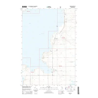
2014 Map of Garden
USGS Topo · Published 2014About this map
Garden serves as the focal point of this coastal survey, situated where the waters of Garden Bay meet the land at the head of the Garden Peninsula. The village layout is clearly defined by local thoroughfares such as State St and Garden Ave, which connect the settlement to the surrounding landscape. The area is notable for its numerous burial grounds, including the New Garden Cem to the north and small family plots like the Cousineau-Potvin Family Cem and Bailey Family Cem. These sites, along with the Kates Bay Cem, provide significant touchstones for local genealogical research.
Find a feature on this map
45 named features on this map. Tap any name to fly to it.
Don’t see what you’re looking for? This feature index may not catch every label — zoom into the map to look around manually.
Map Details
Editions of this 2014 Garden Map
This is the sole edition of this map. No revisions or reprints were ever made.
Other maps of this area

1931 · Cooks NW
USGS Topo · 1:31,680

1932 · Burnt Bluff NE
USGS Topo · 1:31,680

1932 · Burnt Bluff NW
USGS Topo · 1:31,680

1932 · Garden NW and SW
USGS Topo · 1:31,680

1932 · Garden SE
USGS Topo · 1:31,680

1932 · Garden NE
USGS Topo · 1:31,680

1954 · Escanaba
USGS Topo · 1:250,000

1957 · Escanaba
USGS Topo · 1:250,000

1958 · Escanaba
USGS Topo · 1:250,000

1958 · Cooks
USGS Topo · 1:62,500