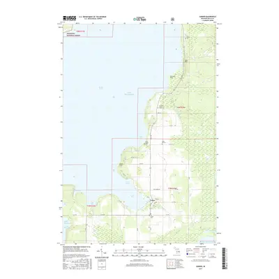
2017 Map of Garden
USGS Topo · Published 2017About this map
The village of Garden serves as the focal point of this coastal survey along the eastern shores of Big Bay de Noc. Positioned on the Garden Peninsula, the settlement's layout is defined by the intersection of Mill St and Water St, surrounded by a series of protective inlets including Garden Bay, Vans Harbor, and Kates Bay. The map is particularly valuable for genealogical research, documenting several distinct burial sites such as the Old Garden Cem, the Cousineau-Potvin Family Cem, and the Bailey Family Cem. To the north, the terrain rises toward Jacks Bluff and Valentine Point, while the northwestern corner of the quadrangle reaches into the protected lands of the Hiawatha National Forest. Small inland water bodies like Buck Fever Lake and Halfmoon Lake dot the eastern interior, reflecting the wetland characteristics of this Upper Peninsula landscape.
Find a feature on this map
48 named features on this map. Tap any name to fly to it.
Don’t see what you’re looking for? This feature index may not catch every label — zoom into the map to look around manually.
Map Details
Editions of this 2017 Garden Map
This is the sole edition of this map. No revisions or reprints were ever made.
Other maps of this area

1931 · Cooks NW
USGS Topo · 1:31,680

1932 · Burnt Bluff NE
USGS Topo · 1:31,680

1932 · Burnt Bluff NW
USGS Topo · 1:31,680

1932 · Garden NW and SW
USGS Topo · 1:31,680

1932 · Garden SE
USGS Topo · 1:31,680

1932 · Garden NE
USGS Topo · 1:31,680

1954 · Escanaba
USGS Topo · 1:250,000

1957 · Escanaba
USGS Topo · 1:250,000

1958 · Escanaba
USGS Topo · 1:250,000

1958 · Cooks
USGS Topo · 1:62,500