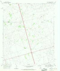
1968 Map of Gardendale
USGS Topo · Published 1970About this map
The Permian Basin oil economy defines the landscape of this 1960s survey along the border of Andrews and Ector counties. Industrial development is ubiquitous, characterized by the sprawling Midland Farms Oil Field and North Cowden Oil Field. A dense network of pipelines and unimproved roads crisscross the terrain, connecting a series of named water sources essential for desert operations, such as Ward Windmill, Mutt Windmill, and the Steel Tower Windmill.
Find a feature on this map
20 named features on this map. Tap any name to fly to it.
Don’t see what you’re looking for? This feature index may not catch every label — zoom into the map to look around manually.
Map Details
Editions of this 1968 Gardendale Map
2 editions found
Other maps of this area

1954 · Hobbs
USGS Topo · 1:250,000

1954 · Pecos
USGS Topo · 1:250,000

1957 · Pecos
USGS Topo · 1:250,000

1958 · Hobbs
USGS Topo · 1:250,000

1964 · Odessa NE
USGS Topo · 1:24,000

1964 · Odessa NW
USGS Topo · 1:24,000

1965 · Goldsmith
USGS Topo · 1:24,000

1967 · North Cowden
USGS Topo · 1:24,000

1968 · Baird Lake
USGS Topo · 1:24,000

1968 · Gardendale NW
USGS Topo · 1:24,000