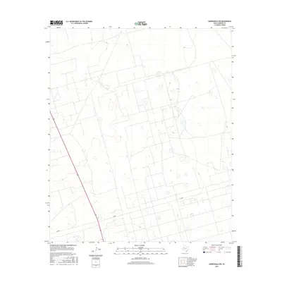
2016 Map of Gardendale NW
USGS Topo · Published 2016About this map
The vast, geometric ranchlands of Andrews County are defined by a high-desert grid of service roads and the prominent diagonal of US Highway 385. This landscape, characterized by ephemeral wetlands and depressions known as playas, reveals the structured layout of West Texas oil and gas fields where secondary roads like Sw 8000 and Se 8000 carve through the scrub. The scarcity of named settlements on this particular sheet underscores the scale of industrial and agricultural operations in the Permian Basin during the mid-2010s, where land use is dictated by the extraction of resources rather than dense residential development.
Find a feature on this map
3 named features on this map. Tap any name to fly to it.
Don’t see what you’re looking for? This feature index may not catch every label — zoom into the map to look around manually.
Map Details
Editions of this 2016 Gardendale NW Map
This is the sole edition of this map. No revisions or reprints were ever made.
Other maps of this area

1954 · Hobbs
USGS Topo · 1:250,000

1958 · Hobbs
USGS Topo · 1:250,000

1963 · Andrews
USGS Topo · 1:24,000

1967 · North Cowden
USGS Topo · 1:24,000

1968 · Baird Lake
USGS Topo · 1:24,000

1968 · Gardendale NW
USGS Topo · 1:24,000

1968 · Clabber Hill Ranch
USGS Topo · 1:24,000
1968 · Hackberry Lake
USGS Topo · 1:24,000
1968 · Gardendale
USGS Topo · 1:24,000

1971 · Five Wells Ranch SE
USGS Topo · 1:24,000