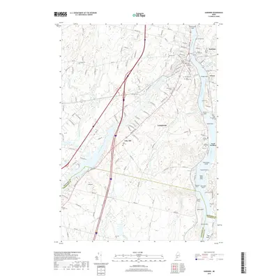
2018 Map of Gardiner
USGS Topo · Published 2018About this map
The Kennebec River corridor defines the geography of this survey, where the river winds past the settlements of Farmingdale, Randolph, and South Gardiner. The landscape is notably dotted with legacy burial sites, ranging from the Christ Church Cenotaphs and Oak Grove Cem to smaller, family-named plots like the Brown Family Cem and Babb Cem. Navigation and industry are suggested by the presence of Upper Sands Shoal and the landmark Iron Mine Hill overlooking the junction of Cobbosseecontee Stream. The map also captures the confluence of several water bodies, including Togus Stream and the Abagadasset River, alongside low-lying river features such as The Sands Island and Nehumkeag Island. This detailed record illustrates the persistent relationship between the tidal river and the established residential communities of Kennebec County.
Find a feature on this map
133 named features on this map. Tap any name to fly to it.
Don’t see what you’re looking for? This feature index may not catch every label — zoom into the map to look around manually.
Map Details
Editions of this 2018 Gardiner Map
This is the sole edition of this map. No revisions or reprints were ever made.
Other maps of this area

1892 · Gardiner
USGS Topo · 1:62,500

1892 · Augusta
USGS Topo · 1:62,500

1893 · Vassalboro
USGS Topo · 1:62,500

1893 · Wiscasset
USGS Topo · 1:62,500

1898 · Vassalboro
USGS Topo · 1:62,500

1941 · Vassalboro
USGS Topo · 1:62,500

1941 · Augusta
USGS Topo · 1:62,500

1943 · Augusta
USGS Topo · 1:62,500

1943 · Gardiner
USGS Topo · 1:62,500

1943 · Vassalboro
USGS Topo · 1:62,500