
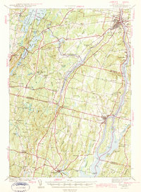
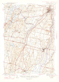
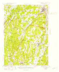
1943 Map of Gardiner
USGS Topo · Published 1943About this map
The Kennebec River corridor defines this wartime survey, acting as a major artery for the Maine Central railroad and a string of riverside communities including Gardiner, South Gardiner, and Richmond. The landscape is characterized by its transition from industrial riverfronts to inland agricultural and recreational spaces, notably around Cobbosseecontee Lake and the Tacoma Lake chain.
Find a feature on this map
102 named features on this map. Tap any name to fly to it.
Don’t see what you’re looking for? This feature index may not catch every label — zoom into the map to look around manually.
Map Details
Editions of this 1943 Gardiner Map
4 editions found
Other maps of this area

1892 · Gardiner
USGS Topo · 1:62,500

1892 · Freeport
USGS Topo · 1:62,500

1892 · Augusta
USGS Topo · 1:62,500

1893 · Vassalboro
USGS Topo · 1:62,500

1893 · Wiscasset
USGS Topo · 1:62,500

1893 · Boothbay
USGS Topo · 1:62,500

1894 · Bath
USGS Topo · 1:62,500

1898 · Vassalboro
USGS Topo · 1:62,500

1908 · Lewiston
USGS Topo · 1:62,500

1910 · Livermore
USGS Topo · 1:62,500