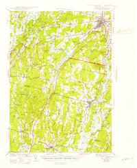
1943 Map of Gardiner
USGS Topo · Published 1947About this map
The Kennebec River corridor defines this mid-coast Maine landscape, serving as a vital artery for the Maine Central railroad and a string of riverside settlements including Gardiner, South Gardiner, and the ice-industry outpost of Iceboro. Moving inland, the terrain shifts from tidal riverbanks to a network of interior lakes and ponds like Cobbosseecontee Lake and the Tacoma lake system. The map reveals a dense rural fabric of the early 1940s, marked by numerous small crossroads such as Litchfield Cors and Richmond Cor. Genealogists will find significant value in the distribution of family-named schools and burial grounds, including the Reed Cem and Curtis Cem, as well as the Richmond Camp Ground. The land-use pattern is deeply tied to the waterways, with the Abagadasset River and Cathance River winding through the southern townships of Bowdoin Center and Bowdoinham.
Find a feature on this map
115 named features on this map. Tap any name to fly to it.
Don’t see what you’re looking for? This feature index may not catch every label — zoom into the map to look around manually.
Map Details
Editions of this 1943 Gardiner Map
4 editions found

Other maps of this area

1892 · Gardiner
USGS Topo · 1:62,500

1892 · Freeport
USGS Topo · 1:62,500

1892 · Augusta
USGS Topo · 1:62,500

1893 · Vassalboro
USGS Topo · 1:62,500

1893 · Wiscasset
USGS Topo · 1:62,500

1893 · Boothbay
USGS Topo · 1:62,500

1894 · Bath
USGS Topo · 1:62,500

1898 · Vassalboro
USGS Topo · 1:62,500

1908 · Lewiston
USGS Topo · 1:62,500

1910 · Livermore
USGS Topo · 1:62,500