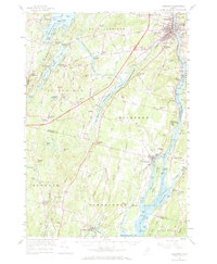
1957 Map of Gardiner
USGS Topo · Published 1971About this map
The Kennebec River corridor defines this mid-century survey, anchoring the industrial and civic centers of Gardiner and Richmond. The river's significance is highlighted by the Swan Island State Game Preserve and the navigable Lovejoy Narrows, while the Maine Central RR tracks the western bank through small riverfront settlements like Iceboro. Inland, the landscape transitions to a network of lakes and agricultural crossroads. The Tacoma Lakes and Cobbosseecontee Lake dominate the northwestern terrain, surrounded by established community markers like Litchfield Academy and Litchfield Corners. The map documents a period of infrastructure modernization, showing the path of the Maine Turnpike as it cuts through the rural townships of Litchfield and Richmond, contrasting with the older Arnold Highway and numerous local schools such as the Adams Sch and Jaques Sch.
Find a feature on this map
96 named features on this map. Tap any name to fly to it.
Don’t see what you’re looking for? This feature index may not catch every label — zoom into the map to look around manually.
Map Details
Editions of this 1957 Gardiner Map
3 editions found
Other maps of this area

1892 · Gardiner
USGS Topo · 1:62,500

1892 · Freeport
USGS Topo · 1:62,500

1892 · Augusta
USGS Topo · 1:62,500

1893 · Vassalboro
USGS Topo · 1:62,500

1893 · Wiscasset
USGS Topo · 1:62,500

1893 · Boothbay
USGS Topo · 1:62,500

1894 · Bath
USGS Topo · 1:62,500

1898 · Vassalboro
USGS Topo · 1:62,500

1908 · Lewiston
USGS Topo · 1:62,500

1910 · Livermore
USGS Topo · 1:62,500