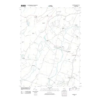
2010 Map of Gardiner
USGS Topo · Published 2010About this map
The Shawangunk Mountains rise sharply in the northwest corner of this quadrangle, featuring landmarks like Gertrudes Nose and the high waters of Lake Minnewaska near Wildmere House. Below the ridge, the landscape transitions into the fertile Wallkill River valley, where the agricultural legacy of Ulster County is evident at Jenkins And Lueken Orchard and Dolan Orchards. The settlement of Gardiner serves as a central hub, connected to outlying hamlets like Bruynswick and Ireland Corners via a network of historic routes including Albany Post Rd. The local industrial past is anchored by the Tuthilltown Grist Mill near Tuthilltown, while the repurposing of the Wallkill Valley Rail Trl reflects a modern shift in how the community interacts with the corridor that once fueled its growth.
Find a feature on this map
91 named features on this map. Tap any name to fly to it.
Don’t see what you’re looking for? This feature index may not catch every label — zoom into the map to look around manually.
Map Details
Editions of this 2010 Gardiner Map
This is the sole edition of this map. No revisions or reprints were ever made.
Other maps of this area

1901 · Rosendale
USGS Topo · 1:62,500

1903 · Newburg
USGS Topo · 1:62,500

1903 · Rosendale
USGS Topo · 1:62,500

1903 · Slide Mountain
USGS Topo · 1:62,500

1904 · Ellenville
USGS Topo · 1:62,500

1905 · Slide Mountain
USGS Topo · 1:62,500

1906 · Ellenville
USGS Topo · 1:62,500
1942 · Rosendale
USGS Topo · 1:24,000
1942 · Walden
USGS Topo · 1:24,000

1942 · Kerhonkson
USGS Topo · 1:24,000