
1903 Map of Gardiners Island
USGS Topo · Published 1962About this map
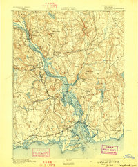
Gardiners Bay and the surrounding islands of eastern Long Island are captured here during a transitional era of coastal defense and maritime commerce. The map centers on the prominent hook of Gardiners Island, featuring landmarks such as Whale Hill, Bostwick Bay, and Tobacco Lot Bay. To the north, Fort Terry stands on Plum Island, marking a significant military presence overlooking Plum Gut and the strategic steamboat routes that navigated these waters between Long Island Sound and Block Island Sound.
Find a feature on this map
53 named features on this map. Tap any name to fly to it.
Don’t see what you’re looking for? This feature index may not catch every label — zoom into the map to look around manually.
Map Details
Editions of this 1903 Gardiners Island Map
This is the sole edition of this map. No revisions or reprints were ever made.
Other maps of this area

1889 · Stonington
USGS Topo · 1:62,500

1892 · New London
USGS Topo · 1:62,500

1893 · Stonington
USGS Topo · 1:62,500

1893 · New London
USGS Topo · 1:62,500
1893 · Saybrook
USGS Topo · 1:62,500

1903 · Sag Harbor
USGS Topo · 1:62,500
1904 · Sag Harbor
USGS Topo · 1:62,500

1904 · Shelter Island
USGS Topo · 1:62,500
1904 · Easthampton
USGS Topo · 1:62,500

1904 · Gardiners Island
USGS Topo · 1:62,500
Featured Places
- East Hampton, NY
- Southold, NY
- Springs, East Hampton
- Northwest Harbor, East Hampton
- Montauk, East Hampton