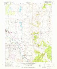
1969 Map of Gardnerville
USGS Topo · Published 1976About this map
Carson Valley serves as the focal point for this late-1960s survey, illustrating a landscape defined by complex water management and rural Nevada settlement. The community of Gardnerville is situated along the western edge, while Dresslerville sits further south near the winding path of the East Fork Carson River. A sophisticated network of irrigation and drainage features dominates the valley floor, including the Allerman Canal, Upper Virginia Canal, and numerous sloughs like Cottonwood Slough and Henningon Slough. To the east, the terrain rises toward the Pine Nut Creek drainage, where the environment shifts from irrigated agriculture to more arid highlands marked by a Jeep Trail and several small mining prospects. The inclusion of the Lahontan National Fish Hatchery and the Indian Reservation Boundary highlights the intersection of federal, state, and tribal land use during this era.
Find a feature on this map
47 named features on this map. Tap any name to fly to it.
Don’t see what you’re looking for? This feature index may not catch every label — zoom into the map to look around manually.
Map Details
Editions of this 1969 Gardnerville Map
3 editions found
Other maps of this area

1889 · Markleeville
USGS Topo · 1:125,000

1891 · Carson
USGS Topo · 1:125,000

1891 · Markleeville
USGS Topo · 1:125,000

1893 · Carson
USGS Topo · 1:125,000

1893 · Markleeville
USGS Topo · 1:125,000

1948 · Walker Lake
USGS Topo · 1:250,000

1956 · Freel Peak
USGS Topo · 1:62,500

1956 · Dayton
USGS Topo · 1:62,500

1956 · Carson City
USGS Topo · 1:62,500

1957 · Walker Lake
USGS Topo · 1:250,000