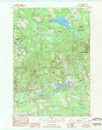
1983 Map of Garland
USGS Topo · Published 1984About this map
Garland serves as the primary hub of this rural landscape, situated at the junction of several local routes that connect scattered crossroads settlements in the 1980s. The region is defined by its numerous small corners and historic mills, including Dover South Mills and Silvers Mills, which point to a localized economy built around the area's water resources. Significant water bodies like Branns Mill Pond and Garland Pond dominate the terrain, while the Penobscot-Piscataquis Wildlife Management Area covers substantial acreage in the north and east, reflecting a transition toward conservation and forest management. Local history is anchored by family-named landmarks like Norton Hill and Preble Hill, along with genealogical sites such as Evergreen Cem. The southern edge features the Dexter Regional Airport, marking a modern addition to this otherwise traditional Maine countryside of streams and brooks.
Find a feature on this map
58 named features on this map. Tap any name to fly to it.
Don’t see what you’re looking for? This feature index may not catch every label — zoom into the map to look around manually.
Map Details
Editions of this 1983 Garland Map
2 editions found
Other maps of this area

1930 · Pittsfield
USGS Topo · 1:48,000

1931 · Stetson
USGS Topo · 1:48,000

1932 · Dover-Foxcroft
USGS Topo · 1:48,000

1932 · Pittsfield
USGS Topo · 1:62,500

1933 · Pittsfield
USGS Topo · 1:62,500

1933 · Guilford
USGS Topo · 1:62,500

1935 · Dover-Foxcroft
USGS Topo · 1:62,500

1935 · Stetson
USGS Topo · 1:62,500

1937 · Guilford
USGS Topo · 1:62,500

1948 · Bangor
USGS Topo · 1:250,000