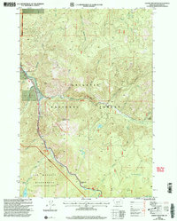
2000 Map of Garnet Mountain
USGS Topo · Published 2005About this map
The Gallatin River carves a deep canyon through this portion of the Gallatin National Forest, serving as the primary corridor for movement between the high mountain peaks. Along the western edge of the river, the Lee Metcalf Wilderness protects a high-elevation landscape marked by dramatic water features like Hoodoo Cascade and Lava Lake. The settlement at Shenango sits at a narrow point in the valley where Beckman Creek and Logger Creek meet the main river channel.
Find a feature on this map
35 named features on this map. Tap any name to fly to it.
Don’t see what you’re looking for? This feature index may not catch every label — zoom into the map to look around manually.
Map Details
Editions of this 2000 Garnet Mountain Map
This is the sole edition of this map. No revisions or reprints were ever made.
Other maps of this area

1888 · Three Forks
USGS Topo · 1:250,000

1894 · Three Forks
USGS Topo · 1:250,000

1895 · Three Forks
USGS Topo · 1:250,000

1947 · Bozeman
USGS Topo · 1:250,000

1948 · Bozeman
USGS Topo · 1:250,000

1949 · Anceney
USGS Topo · 1:62,500

1950 · Spanish Peaks
USGS Topo · 1:62,500

1953 · Bozeman
USGS Topo · 1:62,500

1955 · Bozeman
USGS Topo · 1:250,000

1955 · Garnet Mountain
USGS Topo · 1:62,500