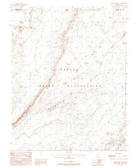
1988 Map of Garnet Ridge
USGS Topo · Published 1988About this map
Comb Ridge dominates this 1988 landscape, a massive geological uplift that cuts a dramatic path across the high desert of the Navajo Indian Reservation. This provisional survey provides a detailed look at the borderlands where Apache County, Arizona, meets San Juan County, Utah. The terrain is characterized by complex erosion patterns, notably within Cane Valley and along the sharp spine of Garnet Ridge. Water is a scarce but defining presence, found at a single mapped Spring and the Dennehotso Laguna in the southeast corner. Sparse human footprints in this remote area are limited to unimproved roads, a Drill Hole, and a utility corridor following the southern reach of Creek. The map is an essential record of the natural topography and traditional land boundaries of the Navajo Nation during the late twentieth century.
Find a feature on this map
16 named features on this map. Tap any name to fly to it.
Don’t see what you’re looking for? This feature index may not catch every label — zoom into the map to look around manually.
Map Details
Editions of this 1988 Garnet Ridge Map
This is the sole edition of this map. No revisions or reprints were ever made.
Other maps of this area

1886 · Abajo
USGS Topo · 1:250,000

1892 · Abajo
USGS Topo · 1:250,000

1892 · Canyon De Chelly
USGS Topo · 1:250,000

1893 · Abajo
USGS Topo · 1:250,000

1952 · Bluff 3 SE
USGS Topo · 1:24,000

1952 · Dinnehotso
USGS Topo · 1:62,500
1952 · Bluff 3 SW
USGS Topo · 1:24,000

1952 · Setsiltso Springs 2 NW
USGS Topo · 1:24,000

1952 · Setsiltso Springs 2 SW
USGS Topo · 1:24,000

1952 · Setsiltso Springs 2 SE
USGS Topo · 1:24,000