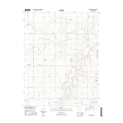
2015 Map of Garnett West
USGS Topo · Published 2015About this map
Pottawatomie Cr and its tributaries define the rolling landscape of eastern Kansas just west of the county seat. This area maintains a strong agricultural and communal character, evidenced by the scattered burial grounds that serve local congregations and families, such as the Amish Cem and Baptist Cem. The small settlement of Glenlock sits at a rural crossroads, while the western fringes of Garnett appear on the eastern edge of the survey, where the grid of city streets like W 4th Ave and W 11th Ave transitions into a network of numbered range roads. The southern portion of the map is dominated by the Cedar Valley Reservoir, a significant water feature fed by Cedar Cr. These waterways, including Fish Cr and Sac Cr, have long shaped the settlement patterns and road placements throughout Anderson County.
Find a feature on this map
39 named features on this map. Tap any name to fly to it.
Don’t see what you’re looking for? This feature index may not catch every label — zoom into the map to look around manually.
Map Details
Editions of this 2015 Garnett West Map
This is the sole edition of this map. No revisions or reprints were ever made.
Other maps of this area

1885 · Garnett
USGS Topo · 1:125,000

1894 · Garnett
USGS Topo · 1:125,000

1947 · Lawrence
USGS Topo · 1:250,000

1950 · Lawrence
USGS Topo · 1:250,000

1956 · Williamsburg
USGS Topo · 1:24,000

1956 · Lawrence
USGS Topo · 1:250,000

1961 · Lawrence
USGS Topo · 1:250,000
1965 · Richmond
USGS Topo · 1:24,000
1966 · Bush City
USGS Topo · 1:24,000
1966 · Westphalia
USGS Topo · 1:24,000