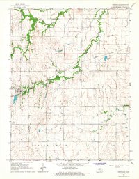
1966 Map of Westphalia
USGS Topo · Published 1967About this map
Westphalia stands as the primary hub of this Anderson County landscape in the mid-1960s, its town grid centered near the Missouri Pacific railroad line. The surrounding terrain is defined by a dense network of drainage, including the winding paths of Pottawatomie Creek, Thomas Creek, and Cherry Creek. Local history and genealogy are anchored by landmarks such as St Teresa Cemetery and the Cherry Mound Church, which serve the rural communities outside the main settlement. The geography transitions between the townships of Westphalia, Welda, Indian Creek, and Ozark. Evidence of local infrastructure is seen at the Waterworks and Spencer Lake, while the agricultural character of the region is reinforced by the numerous small tributaries like Cedar Creek that carve through the prairie landscape.
Find a feature on this map
16 named features on this map. Tap any name to fly to it.
Don’t see what you’re looking for? This feature index may not catch every label — zoom into the map to look around manually.
Map Details
Editions of this 1966 Westphalia Map
This is the sole edition of this map. No revisions or reprints were ever made.
Other maps of this area

1885 · Burlington
USGS Topo · 1:125,000

1885 · Garnett
USGS Topo · 1:125,000

1894 · Garnett
USGS Topo · 1:125,000

1894 · Burlington
USGS Topo · 1:125,000

1947 · Lawrence
USGS Topo · 1:250,000

1950 · Lawrence
USGS Topo · 1:250,000

1956 · Lawrence
USGS Topo · 1:250,000

1961 · Lawrence
USGS Topo · 1:250,000
1966 · Welda
USGS Topo · 1:24,000
1966 · Harris
USGS Topo · 1:24,000