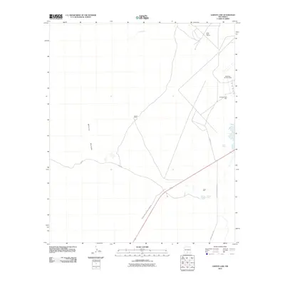
2010 Map of Garton Lake
USGS Topo · Published 2010About this map
White Sands National Monument and the surrounding basin are the primary focus of this modern topographic study, showing the unique desert landscape of Otero County in the early 21st century. The map details the intersection of ecological preservation and military operations, with the White Sands Missile Range and Holloman Air Force Base dominating the eastern and northern reaches. The vast expanse of White Sands is broken by limited water features and human structures, such as Walters Ranch and the Lost River drainage. Notable hydrological landmarks include Garton Lake, the Garton Water Well, and Hurtz Spring, which reflect the sparse but critical water resources in this arid environment. The presence of White Sands Gypsum and the Holloman Lake Dam further illustrate the region's geological and managed water characteristics.
Find a feature on this map
16 named features on this map. Tap any name to fly to it.
Don’t see what you’re looking for? This feature index may not catch every label — zoom into the map to look around manually.
Map Details
Editions of this 2010 Garton Lake Map
This is the sole edition of this map. No revisions or reprints were ever made.
Other maps of this area

1916 · Point Of Sands
USGS Topo · 1:125,000

1947 · Point Of Sands 2
USGS Topo · 1:62,500

1947 · Lake Lucero
USGS Topo · 1:62,500

1948 · Tres Hermanos
USGS Topo · 1:62,500

1948 · Holloman
USGS Topo · 1:62,500
1950 · Lake Lucero NE
USGS Topo · 1:24,000

1955 · Las Cruces
USGS Topo · 1:250,000

1958 · Las Cruces
USGS Topo · 1:250,000
1976 · Holloman SW
USGS Topo · 1:24,000
1976 · Holloman NE
USGS Topo · 1:24,000