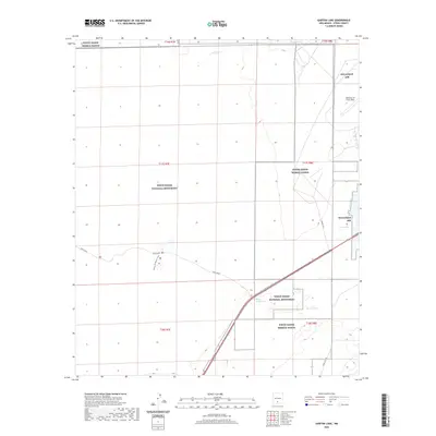
2020 Map of Garton Lake
USGS Topo · Published 2020About this map
White Sands National Monument dominates this desert landscape, where the shifting gypsum sands meet the heavy military presence of the Tularosa Basin. The map details the interface between public recreation and restricted federal lands, notably the sprawling White Sands Missile Range and Holloman AFB. Visitors to the monument can trace Dunes Drive as it winds into the white dunes, passing the Dune Life Nature Trail and the controlled entry at the White Sands Gate. Water is a scarce but defining presence in this arid environment, represented by the ephemeral Lost River and small oases like Bradford Spring, Hurtz Spring, and the eponymous Garton Lake. These features reveal the unique hydrological and administrative boundaries of this modern New Mexico landscape.
Find a feature on this map
17 named features on this map. Tap any name to fly to it.
Don’t see what you’re looking for? This feature index may not catch every label — zoom into the map to look around manually.
Map Details
Editions of this 2020 Garton Lake Map
This is the sole edition of this map. No revisions or reprints were ever made.
Other maps of this area

1916 · Point Of Sands
USGS Topo · 1:125,000

1947 · Point Of Sands 2
USGS Topo · 1:62,500

1947 · Lake Lucero
USGS Topo · 1:62,500

1948 · Tres Hermanos
USGS Topo · 1:62,500

1948 · Holloman
USGS Topo · 1:62,500
1950 · Lake Lucero NE
USGS Topo · 1:24,000

1955 · Las Cruces
USGS Topo · 1:250,000

1958 · Las Cruces
USGS Topo · 1:250,000
1976 · Holloman SW
USGS Topo · 1:24,000
1976 · Holloman NE
USGS Topo · 1:24,000