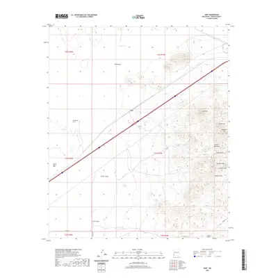
2020 Map of Gary
USGS Topo · Published 2020About this map
The settlement of Gary sits along a major transportation corridor in the high desert of Hidalgo County. This landscape is defined by the sharp transition between the alluvial basins and the southern reaches of the Pyramid Mountains. To the east, the terrain rises significantly toward summits like Lee Peak, Aberdeen Peak, and Lookout Hill, while the western portion of the map is dominated by the broad, dry expanses of Tobosa Flats and South Alkali Flat.
Find a feature on this map
24 named features on this map. Tap any name to fly to it.
Don’t see what you’re looking for? This feature index may not catch every label — zoom into the map to look around manually.
Map Details
Editions of this 2020 Gary Map
This is the sole edition of this map. No revisions or reprints were ever made.
Other maps of this area

1954 · Silver City
USGS Topo · 1:250,000

1958 · Silver City
USGS Topo · 1:250,000

1962 · Silver City
USGS Topo · 1:250,000

1963 · Lordsburg
USGS Topo · 1:24,000

1963 · Culberson Ranch
USGS Topo · 1:24,000

1964 · Pyramid Peak
USGS Topo · 1:24,000
1964 · Summit
USGS Topo · 1:24,000
1964 · Mondel
USGS Topo · 1:24,000

1964 · Gary
USGS Topo · 1:24,000
1964 · Ninemile Hill
USGS Topo · 1:24,000