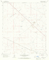
1964 Map of Ninemile Hill
USGS Topo · Published 1966About this map
Lordsburg Mesa dominates this 1960s landscape, providing a clear picture of high-desert ranching and infrastructure in Hidalgo County. The terrain is marked by a sophisticated water management system essential for livestock, including numerous catchments like Odell Tank, Little Highway Tank, and the House Pasture Tank. This network supported local operations such as the Box M Ranch, located just north of the Southern Pacific rail line.
Find a feature on this map
26 named features on this map. Tap any name to fly to it.
Don’t see what you’re looking for? This feature index may not catch every label — zoom into the map to look around manually.
Map Details
Editions of this 1964 Ninemile Hill Map
2 editions found
Other maps of this area

1954 · Silver City
USGS Topo · 1:250,000

1958 · Silver City
USGS Topo · 1:250,000

1959 · Redrock
USGS Topo · 1:62,500

1959 · Canador Peak
USGS Topo · 1:62,500

1962 · Silver City
USGS Topo · 1:250,000

1963 · Lordsburg
USGS Topo · 1:24,000

1963 · Culberson Ranch
USGS Topo · 1:24,000
1964 · Summit
USGS Topo · 1:24,000
1964 · Mondel
USGS Topo · 1:24,000

1964 · Gary
USGS Topo · 1:24,000