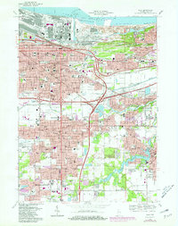
1968 Map of Gary
USGS Topo · Published 1980About this map
The industrial and residential expansion of Gary is captured here during a period of significant growth, showing the city's complex grid pressed against the Lake Michigan shoreline. Heavily concentrated transportation corridors, including the Indiana East-West Toll Road and numerous rail lines like the Elgin Joliet and Eastern Ry, define the urban geography. The map provides a look at established neighborhoods such as Tolleston, Aetna, and Glen Park, while highlighting the early footprint of the Indiana University Northwest Campus.
Find a feature on this map
89 named features on this map. Tap any name to fly to it.
Don’t see what you’re looking for? This feature index may not catch every label — zoom into the map to look around manually.
Map Details
Editions of this 1968 Gary Map
3 editions found
Other maps of this area

1900 · Toleston
USGS Topo · 1:62,500

1934 · Porter
USGS Topo · 1:48,000

1940 · Porter
USGS Topo · 1:62,500

1953 · St. John
USGS Topo · 1:24,000

1953 · Palmer
USGS Topo · 1:24,000

1953 · Gary
USGS Topo · 1:24,000

1953 · Crown Point
USGS Topo · 1:24,000
1953 · Whiting
USGS Topo · 1:24,000

1953 · Garyton
USGS Topo · 1:24,000

1953 · Ogden Dunes
USGS Topo · 1:24,000