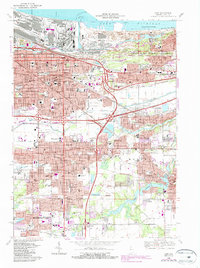
1968 Map of Gary
USGS Topo · Published 1987About this map
Gary's industrial heart and urban expansion are documented in this late-century survey, capturing a landscape defined by the Grand Calumet River and the sprawling steel infrastructure of Gary Harbor. The map illustrates the dense residential blocks of Tolleston, Miller, and Aetna as they grew toward the Indiana Dunes National Lakeshore. The transportation network is remarkably complex, showing the Chicago South Shore and South Bend RR and Conrail lines alongside the modern Indiana Toll Road and Tri-State Highway. Genealogists will find significant detail in the numerous local institutions, from Holy Angels Sch and the Salvationist Fathers Monastery to large burial grounds like Oak Hill Cemetery and Crown Hill Cemetery. To the south, the corporate boundaries of Hobart and Merrillville show the transition from industrial lakefront to suburban development near George Lake.
Find a feature on this map
77 named features on this map. Tap any name to fly to it.
Don’t see what you’re looking for? This feature index may not catch every label — zoom into the map to look around manually.
Map Details
Editions of this 1968 Gary Map
3 editions found
Other maps of this area

1900 · Toleston
USGS Topo · 1:62,500

1934 · Porter
USGS Topo · 1:48,000

1940 · Porter
USGS Topo · 1:62,500

1953 · St. John
USGS Topo · 1:24,000

1953 · Palmer
USGS Topo · 1:24,000

1953 · Gary
USGS Topo · 1:24,000

1953 · Crown Point
USGS Topo · 1:24,000
1953 · Whiting
USGS Topo · 1:24,000

1953 · Garyton
USGS Topo · 1:24,000

1953 · Ogden Dunes
USGS Topo · 1:24,000