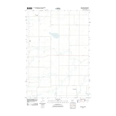
2010 Map of Gary NW
USGS Topo · Published 2010About this map
Salt Lake sits at the center of this 2010 topographic survey of the borderlands between Deuel County, South Dakota, and Lac qui Parle County, Minnesota. The landscape is defined by its drainage network, where Lost Creek and Crow Timber Creek meander across a rectilinear grid of section roads like State Line Rd. These waterways eventually feed into the West Branch Lac qui Parle River in the southeast.
Find a feature on this map
25 named features on this map. Tap any name to fly to it.
Don’t see what you’re looking for? This feature index may not catch every label — zoom into the map to look around manually.
Map Details
Editions of this 2010 Gary NW Map
This is the sole edition of this map. No revisions or reprints were ever made.
Other maps of this area

1953 · Bellingham
USGS Topo · 1:62,500

1953 · Milbank
USGS Topo · 1:250,000

1953 · Watertown
USGS Topo · 1:250,000

1958 · Milbank
USGS Topo · 1:250,000

1958 · Watertown
USGS Topo · 1:250,000

1967 · Gary
USGS Topo · 1:24,000

1967 · Gary SE
USGS Topo · 1:24,000

1967 · Gary NW
USGS Topo · 1:24,000
1967 · Mount Wickham
USGS Topo · 1:24,000

1971 · Marietta
USGS Topo · 1:24,000
Featured Places
- Antelope Valley Township, SD
- Glenwood Township, SD
- Lac qui Parle County, MN
- Deuel County, SD
- Grant County, SD