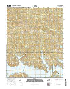
2016 Map of Gasburg
USGS Topo · Published 2016About this map
Lake Gaston dominates the southern portion of this landscape, its intricate shoreline forming numerous coves and points along the border of Brunswick County, Virginia, and Warren and Northampton Counties in North Carolina. The map captures a modern view of this reservoir-centered community, where residential development and recreational infrastructure like Club Dr and Creekside Shores Rd line the water's edge. North of the lake, the terrain transitions into a patchwork of rural land and small settlements connected by a web of local roads such as Gasburg Rd and Emporia Rd. For genealogists and local historians, the area is punctuated by several family and community burial sites, including Kirkland Cem, Pleasant Hill Cem, and Powell Cem. These sites, along with established communities like Gasburg and Ebony, reflect the deep-rooted local history that persists alongside the more recent developments surrounding the lake.
Find a feature on this map
101 named features on this map. Tap any name to fly to it.
Don’t see what you’re looking for? This feature index may not catch every label — zoom into the map to look around manually.
Map Details
Editions of this 2016 Gasburg Map
This is the sole edition of this map. No revisions or reprints were ever made.
Other maps of this area

1919 · White Plains
USGS Topo · 1:48,000

1920 · White Plains
USGS Topo · 1:62,500

1953 · Norfolk
USGS Topo · 1:250,000

1953 · Greensboro
USGS Topo · 1:250,000

1954 · Greensboro
USGS Topo · 1:250,000

1962 · Greensboro
USGS Topo · 1:250,000

1963 · Powellton
USGS Topo · 1:24,000

1963 · Gasburg
USGS Topo · 1:24,000

1963 · Valentines
USGS Topo · 1:24,000

1963 · White Plains
USGS Topo · 1:24,000